Are the Vile Vortices Really All That Vile?

(Originally published on WordPress on March 6, 2022)
For the final entry in my world tour of famous paranormal triangles, let us examine one man's attempt to present a grand unifying theory of anomalous triangles. The man in question is the equal parts renowned and reviled Scottish-born biologist Ivan Terence Sanderson.

I'm here to bust cryptids and chew bubblegum and... well, you know the rest.
Sanderson is probably best remembered today for helping to establish the pseudoscience and subculture of cryptozoology alongside Belgian-French zoologist Bernard Heuvelmans. But he didn't just content himself with the search for folkloric beasts. As the legend of the Bermuda Triangle gained popularity in the 1960s, Sanderson threw his hat in the ring with an apparent discovery he made in 1968. He claimed that the Bermuda Triangle was but one of twelve such regions on Earth where reports of unexplained phenomena and electromagnetic distortions were higher than usual. Five each rested along the Tropics of Cancer and Capricorn, while the other two rested at the North and South Pole. Sanderson believed these vortices were shaped like icosahedrons and that the electromagnetic anomalies were caused by cold air and sea currents.
A trio of Soviet scientists (Nikolai Goncharov, Vyacheslav Morochov, and Valery Makarov) expanded on Sanderson's ideas in a 1973 article titled "Is the Earth a Large Crystal?" In it, they claim that they had discovered that twelve pentagonal plates of cosmic energy cover our planet and that electromagnetic abnormalities occur at the junctions of these plates (62 in all). They additionally claimed that these plates ran parallel with natural phenomena like seismic fracture zones, ocean ridges, animal migratory routes, and even the locations of ancient civilizations (especially those that constructed megaliths). Perhaps Ancient Aliens alumnus David Hatcher Childress puts it best:
...we are speaking about an intelligent geometric pattern into which, theoretically, the Earth and its energies are organized- and possibly in which the ubiquitous megalithic sites are also positioned.
-David Hatcher Childress. “Mapping The World Grid.” Bibliotecapleyades unknown . 28 Apr 2008
Of course, the evidence for this phenomenon being a reality entirely depends on the vortices actually being paranormal hotspots. I've already covered the Bermuda Triangle and the Devil's Triangle in previous articles and found the evidence decidedly lacking. So let us examine the remaining Vile Vortices and see what mysteries lie within.
The South Atlantic Anomaly

The SAA, located off Brazil's southeast coast, is interesting because it is an actual scientific phenomenon that NASA has documented. This is because the vortex is located in the region where the Earth's inner Van Allen radiation belt comes closest to its surface (120 miles to be exact), thus allowing cosmic rays and solar radiation to reach farther into the atmosphere. This thinning often exposes satellites to higher-than-usual radiation levels due to trapped protons, causing technical problems in spacecraft like the Hubble Space Telescope and the International Space Station and sometimes even destroying the craft (as with the Japanese X-ray observatory Hitomi in March of 2016).
While the reasons why spacecraft malfunction over the SAA are fully scientifically understood, that still hasn't stopped paranormal researchers from connecting it to the Bermuda Triangle, thanks to reports that aircraft often experience electronic and navigational malfunctions while flying in the region. The story of the sailboat Tunante II doesn't help in that regard.
According to the Argentine news website Infobae, the sailboat set out from Buenos Aires on August 22nd, 2014, carrying four passengers on a pleasure cruise to Rio de Janeiro. Four days later, the boat's owner, Horacio Robert Morales, sent a distress signal stating that a storm had damaged the vessel's rudder, mast, and engine. While a Norwegian cargo ship sent to assist the Tunante lost sight of it the following day at 4 a.m., records from the company that owned the satellite phones onboard indicated that the vessel had survived the storm. But, despite a search covering over 40,000 square miles, no trace of it was found other than an empty life raft.
Some paranormal researchers have seized upon the timeline of events and the Argentine government's seeming reluctance to carry on the search to suggest that they may be covering up something. However, relatives of the Tunante's passengers have not ruled out the possibility that the sailboat might have run across pirates that may have hijacked the vessel and its occupants and spirited them away to who knows where.
The Algerian Megaliths

Talking about this vortex is tricky, mostly because I can't figure out which megaliths the vortex proponents are talking about. The most commonly cited location associated with the supposed vortex is Djebel Mazala Salluste, located outside Constantine in the northeast corner of Algeria. Oddly enough, though, many sources cite it as south of Timbuktu, which would place it in Mali, while another lists its coordinates as 26.6 North, 4.8 West, which would put it in central Algeria.
In any case, some have connected a spate of plane crashes in the western Sahara region with the vortex at Djebel. For instance, Air Algerie Flight 5017 was carrying 116 passengers and crew from Burkina Faso to Algiers on July 24th, 2014, when it crashed due to ice accretion in the engines, which caused the plane to stall. At least one source, Ranker.com, implicitly connected the crash to the vortex at Djebel, even though the aircraft came down near the southern border of Mali.
Ivan T. Sanderson became interested in the site after hearing reports of two submarines and four smaller boats that vanished off Algeria's coast. I haven't determined which of these he was referring to. I did come across two submarines, the HMS Urge and Minerve, which disappeared in the western Mediterranean in 1942 and 1968, respectively. However, both wrecks have since been located (near Malta and France, respectively), so there's not much of a mystery there.
The Zimbabwe Megaliths

The conical tower in Great Zimbabwe's Great Enclosure (photographed by Flickr user Andrew Moore)
This time the center of the vortex is more concrete, resting around the medieval African city that gave Zimbabwe its name. Constructed between the 9th and 15th centuries CE, it was the capital of a great kingdom back in the late Iron Age, although which kingdom is something that modern archaeologists have yet to figure out. First discovered by Portuguese explorers in 1531, Europeans didn't properly investigate it until 1871.
Of course, because this was the colonial period we're talking about, the British rulers of the country then known as Rhodesia often bent over backward trying to deny the indigenous Shona people their rightful credit for constructing the city. Because, of course, these backward tribesmen couldn't possibly be smart enough to build a structure this sophisticated. The white man needed to bring them into the modern era so they could become smart enough to build structures that sophisticated.

Trust me!
Of course, this begs the obvious question: If the Shona didn't build Zimbabwe, who did? You probably already know where this is going...

While not as famous as the Great Pyramids of Giza and Meroe in that regard, Great Zimbabwe has, on occasion, been caught up in the "ancient astronauts" hysteria that blew up in popularity when the History Channel's Ancient Aliens started airing in 2009. It doesn't matter that archaeologists have demonstrated numerous times that ancient peoples had the tools and resources to construct these sites. In many ways, the ancient astronaut theories have continued the racism that turned the Global South into what it is today.
As for Bermuda Triangle-like activity around Great Zimbabwe, I haven't been able to find much. Some have mentioned planes vanishing in the region, although those same sources describe those disappearances occurring over the Sahara Desert, which is on the complete opposite end of the continent.
Mohenjo-Daro

By Saqib Qayyum - Own work, CC BY-SA 3.0, https://commons.wikimedia.org/w/index.php?curid=31519717
Speaking of ancient aliens, Pakistan's Mohenjo-Daro is another site that has often been connected with alien builders and vile vortices. Ivan Sanderson claimed to have received a letter from a woman who said that planes carrying gold bullion over nearby Afghanistan would go missing. Oddly enough, though, some of their gold cargo would be left behind.
However, the former area of the Indus Valley Civilization is probably better known among ancient astronaut enthusiasts for the persistent rumors that the area bears scars from an impossibly ancient nuclear war dating as far back as 12,000 years ago. Let's examine the supposed evidence, shall we?
-Many passages of the Hindu holy text, the Mahabharata, describe scenes that sound uncomfortably similar to modern descriptions of nuclear warfare. "A single projectile charged with all the power of the universe... An incandescent column of smoke and flame, as bright as 10,000 suns, rose in all its splendor... It was an unknown weapon, an iron thunderbolt, a gigantic messenger of death which reduced to ashes an entire race."
-Mohenjo-Daro itself, along with its sister city Harappa, allegedly are the sites of mass graves, with skeletons scattered across the streets "as if some instant, horrible doom had taken place," in the words of Kisari Mohan Ganguli, who wrote the first complete English translation of the Mahabharata. "People were just lying, unburied, in the streets of the city." Some skeletons also showed radiation levels 50 times greater than average, comparable to modern victims of Hiroshima and Nagasaki.
-The city of Jodhpur, resting in the Thar Desert in northwestern India, is allegedly so radioactive that cancer deaths and birth defects are widespread, to the point that the government has quarantined the area. In addition, an archaeologist named Francis Taylor claimed to have discovered an ancient city nearby, which shows signs of a nuclear blast that killed as many as half a million people.
-Finally, the Lonar crater is located under a lake around 300 miles east of Mumbai. The crater is about 3900 feet in diameter and is not volcanic in origin. Maybe it could be the result of a nuclear explosion, then?
Unlikely, as episode 541 of Brian Dunning's Skeptoid podcast pretty much put paid to all of these ideas:
-He logged onto a searchable online copy of the Mahabharata and found nothing remotely similar to the above passage.
-He found no mention of mass graves in the abundance of archaeological literature available on Mohenjo-Daro, Harappa, or any other excavated sites in the Indus Valley region.
-Jodhpur having radiation levels that high from a nuclear conflict that occurred 8-12,000 years ago makes no sense. Even the strongest nuclear isotopes, like cesium-137 and strontium-90, only have half-lives of 30 years at most. Even Hiroshima and Nagasaki are clean of radiation just three-quarters of a century after the infamous bomb drops. Furthermore, there is absolutely no evidence that Francis Taylor's city of half a million people ever existed.
-The quotes attributed to Ganguli make no sense, as he lived in the 1880s-90s, long before nuclear weapons were conceived.
-Finally, the Lonar crater has been definitively proven to be a meteor crater dating to around 576,000 years ago, with minerals in the surrounding soil being very similar to those found on the Moon.
Indeed, it seems as if everything involving nuclear weapons in ancient India and Pakistan was invented out of whole cloth, most likely by Erich von Daniken in his infamous 1968 book Chariots of the Gods. However, I prefer to save those comments for a list of ancient astronaut theories that I will almost certainly be making sometime in the future. In the meantime, let's move on to...
The Wharton Basin

The Wharton Basin is a region of the ocean floor located between Western Australia and Java. The area has not been mapped since the 1960s, despite being on the boundary of the Indian and Australian tectonic plates, thus making it a very active seismic zone. Indeed, the basin ended up on many geologists’ radar after it was struck by two massive earthquakes on April 11th, 2012, measuring 8.6 and 8.2, respectively. While they occurred too deep underwater to trigger tsunamis (unlike the infamous 9.2 magnitude quake that triggered the deadly Boxing Day tsunami of 2004), geologists are concerned that the quakes may have further destabilized the fault lines that they lie upon.
As for supposed Bermuda Triangle-type activity, there isn’t much to report, probably because the shipping lanes in the region are a bit more lightly traveled than the ones in the Bermuda Triangle. However, one major mystery is connected with the area: the disappearance of Malaysia Airlines Flight 370.

The missing aircraft, 9M-MRO, taking off from Charles de Gaulle Airport in December 2011
The plane took off from Kuala Lumpur, Malaysia, on March 8th, 2014, carrying 239 passengers and crew bound for Beijing. Air traffic control lost communication with the aircraft around 38 minutes after takeoff. However, they could still track it on radar until it suddenly vanished about 200 nautical miles northwest of Penang Island off the northwest coast of Peninsular Malaysia.
Search efforts naturally focused on the South China and Andaman Seas until analysis of satellite communications showed that the plane had last been detected over the Indian Ocean at a point about 1500 miles west of Perth, Australia. There are numerous guesses for how the aircraft got there, ranging from hijacking to being shot down to outlandish theories involving black holes and alien abduction. However, there is probably nothing to connect it directly with the supposed Wharton Basin vortex.
The Hebrides Trench

This vortex rests in the Pacific Ocean and centers on the Loyalty Islands on the eastern edge of the Coral Sea. The trench, marking the area where the Australian tectonic plate is being subducted under the New Hebrides plate, is around 4.7 miles deep. It is known for its unique wildlife (cusk-eels, prawns, and other crustaceans) and frequent earthquakes. The most recent occurred in February 2021 and measured 7.7 on the moment magnitude scale. And that's the weakest of the many earthquakes listed on the trench's Wikipedia page!
As for supernatural phenomena, one book published by TIME-LIFE called Mysteries of the Unknown describes strange currents and "ocean vortices of water." I'm tempted to believe they may be describing maelstroms here, but I'm not entirely sure.
Perhaps the biggest mystery associated with the region is Sandy Island. Captain James Cook described this phantom island, which supposedly rested east of New Caledonia, as early as 1774. It was first formally recognized in 1876 after being "discovered" by a whaling ship named Velocity. The island, roughly the size of Washington D.C., continued to appear on maps as late as 1982, even though cartographers quickly began to doubt its existence. It was finally disproven in November 2012, when the Australian research vessel RV Southern Surveyor surveyed the seafloor and found that no island had ever existed there.
Of course, some quickly jumped to supernatural conclusions when they heard about a whole island disappearing. However, most researchers today believe the Velocity encountered a massive raft of pumice that an underwater volcano had expelled.
The Hamakulia Volcano

Speaking of underwater volcanoes, this one, located northeast of Hawaii's Big Island, is allegedly the site of plane and ship disappearances. There have also been reports of strange lights around the crater and "piezomagnetic effects" that magnetize rocks and cause them to throw navigational equipment out of whack.
This might sound like something out of The X-Files, but scientists understand very well what is happening here. For instance, the blog Cryptoville points out that volcanoes often produce lightning due to static electricity buildup in the ash cloud, a phenomenon that has been widely photographed. Piezomagnetic effects are nothing mysterious either; they are simply another effect produced by natural electric energies during a volcanic eruption, such as the friction of magma flowing underground.
With all this in mind, it's probably no wonder that ships and planes are sometimes lost in this region. It's far from inconceivable that the magnetization of the rocks could mess with a sailing vessel or aircraft's electronic hardware, so there's probably no Bermuda Triangle-type portal to worry about.
What is cause for worry, however, is the matter of excessive tourism putting a strain on the locals.
Easter Island

This South Pacific island (known to its indigenous inhabitants as Rapa Nui) forms the easternmost vertex of the Polynesian Triangle, the other two being New Zealand and Hawaii. Its biggest claim to fame is undoubtedly its over 900 moai, which is the name given to the monolithic humanlike statues that dot its landscape. Carved out of compressed volcanic ash at the quarry Rano Raraku, the natives carried them to all parts of the island between 1250 and 1500. They are commonly agreed to be the representations of deified ancestors, set around the island as protectors.
Sadly, they could not protect the Rapa Nui people from the cruel hammer of colonialism when Europeans first arrived in 1722, bringing disease and slave raiders. While it has been long believed that the Rapa Nui society was already in decline due to deforestation caused by the construction of the moai, a growing number of experts believe the colonizers exaggerated such reports to absolve themselves of blame (because of course they would!). By 1877, the island's native population had been reduced from as much as 3,000 to just 111. Thankfully, the population has increased to 7,750 as of 2017, with most still living on Rapa Nui in the village of Hanga Roa.
Of course, along with colonialism came the arguments that the Rapa Nui peoples couldn't have possibly created the Easter Island moai. There had to be someone else. Perhaps unsurprisingly, the moai have shown up frequently in ancient aliens lore. Not helping with such rumors is the idea often spread that many of the statues (some of which are as much as 33 feet tall) have the entire rest of the body buried underground, which is demonstrably untrue.
However, famed Norwegian adventurer Thor Heyerdahl, upon hearing the common Rapa Nui explanation that the statues literally "walked" to their present positions, conducted an experiment in 1997 alongside Polish engineer Pavel Pavel. A team of 16 people tied a rope around a moai replica's head and base and rocked it back and forth, causing it to literally rock forward.
Sadly, Heyerdahl's experiment had to be cut short due to damage inflicted on the statue. However, a much more successful version of this experiment was performed in 2012 by American archaeologists Terry Hunt and Carl Lipo. They used teams of three people to rock a ten-foot-tall moai replica with ropes tied around its head about 330 feet. You can view the results in this Youtube video on National Geographic's official channel and on the November 7th, 2012 episode of PBS' Nova, titled "Mystery of Easter Island."
The North Pole

The northernmost part of the globe has been well known for causing wonky behavior in compasses. Indeed, the Magnetic North Pole is where all compasses point, so that's to be expected. However, the Arctic is no stranger to mysterious disappearances, perhaps the most notable being the Captain Sir John Franklin expedition in 1845.
Captain Franklin's expedition, consisting of the combined 129-man crew of the HMS Erebus and HMS Terror, set out from Greenhithe, England, on May 19th of that year. European whalers last encountered it in Baffin Bay in July. Subsequent archaeological investigations, writings by the crew, and interviews with local Inuit peoples have since demonstrated that the missing expedition became trapped in ice off Prince William Island in September 1846 and, after losing two dozen men (including Franklin), the crew abandoned both ships and set out for the Canadian mainland in April 1848. All eventually perished due to hypothermia, starvation, lead poisoning, zinc deficiency, and exposure to the harsh polar climate. Indeed, many crew members resorted to cannibalism to no avail.
Indeed, even though the cause of the expedition's demise is well understood by this point (and both ship's wrecks have since been located), that hasn't stopped some from speculating about supernatural foul play. Most notably, the 2007 novel The Terror by Dan Simmons (subsequently adapted as a TV series by AMC in 2018) depicts the expedition being stalked by a demonic beast from Inuit mythology on top of trying to stay alive in the harsh Arctic climate.
The South Pole

The South Pole is also involved in a tale of a doomed expedition. In 1911, the race was on to be the first people to reach the South Pole. The two teams were led by Norwegian explorer Roald Amundsen and British Royal Navy officer Robert Falcon Scott. Amundsen's team became the first humans to set foot on the South Pole on December 14th, 1911. Scott's team reached the pole a little over a month later, on January 17th, 1912.
While Amundsen's team managed to reach their base fully intact, Scott's crew struggled through blizzards and frostbite, having failed to reunite with the dog teams that were supposed to resupply them. They all succumbed to the elements over the next two months, with Scott himself being the last to perish, probably around March 29th. While they failed in their goal of being the first to reach the pole, they did make one significant discovery. Among their corpses, the search parties found 35 pounds of Glossopteris tree fossils from the Permian period (299-252 million years ago), which, along with being the first fossils ever found in Antarctica, proved that the continent had once been in warmer climates and connected to the other continents.
But some believe that Antarctica holds more secrets. For example, notice the strange shape of this mountain...
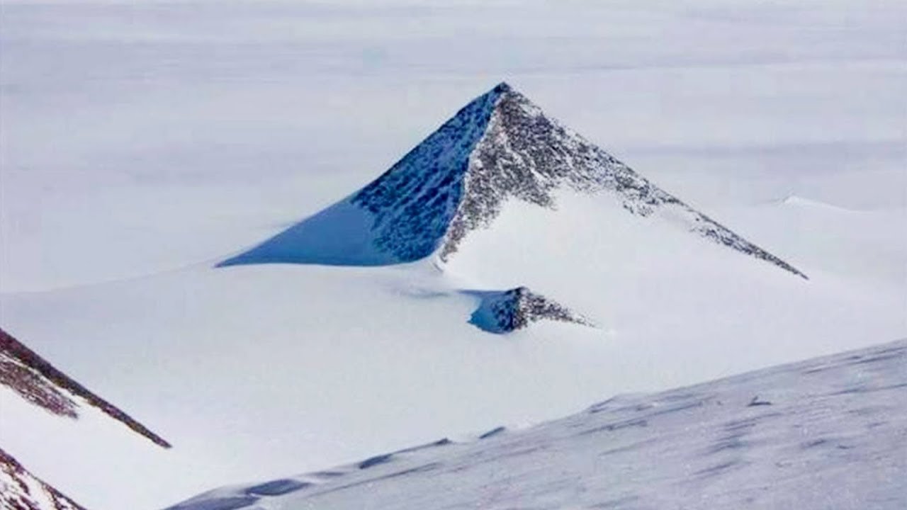
This is one of three mountains in the Ellsworth Range, located at the base of the peninsula that juts out below South America that many say looks suspiciously like pyramids. Some, like the new-age website "Earth. We Are One," have even gone as far as to argue that the pyramids were built by an ancient civilization over 100 million years ago, apparently misinterpreting a study by the Royal Society that showed that Antarctica was lush with vegetation during the Middle Cretaceous. They also incorrectly argue that Antarctica was located at the equator 100 million years ago (it wasn't; global temperatures were warmer then).
In reality, the pyramidal shape of these mountains is the result of glaciers smoothing out their topographies. Indeed, scientists have noted that the mountains are four thousand feet high, making them ten times larger than the Pyramids of Giza. That would be a tall order for any advanced civilization, whether they came from space or not. Indeed, it's hard not to draw comparisons between theories like this and H.P. Lovecraft's 1936 novella At the Mountains of Madness, which, incidentally, may have inspired the 1960 French conspiracy tome The Morning of the Magicians, which in turn was heavily plagiarized by Erich von Daniken in Chariot of the Gods? Interesting.
Also, there's the conspiracy theory about the disputed territory of New Swabia, which has been rumored to have served as a base for the Nazi Party ever since their defeat in 1945, but that's a little too ridiculous to get into here, so let's wrap this up.
And finally, my world tour of paranormal triangles has ended. I hope you had as much fun as I did. Remember to keep your eyes peeled for anything strange if you ever find yourself traveling through one of these triangles. I know I've shown a lot of evidence to suggest that there's nothing supernatural going on in these places, but you never know...